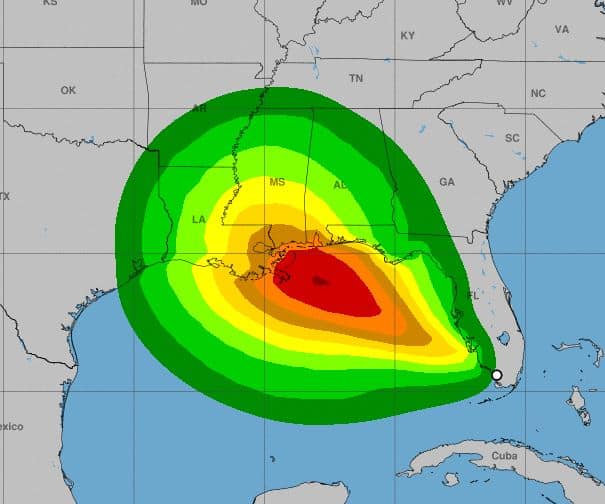
PASCO COUNTY, Fla. - At 200 PM EDT the center of Tropical Storm Sally was located near latitude 25.6 North, longitude 81.6 West. The depression is mo
PASCO COUNTY, Fla. – At 200 PM EDT the center of Tropical Storm Sally was located near latitude 25.6 North, longitude 81.6 West. The depression is moving toward the west near 7 mph (11 km/h), and a turn toward the west-northwest is expected later today or tonight. A west-northwestward or northwestward motion is then expected during the next couple of days. On the forecast track, the center is forecast to move over the southeastern and eastern Gulf of Mexico later today and Sunday, and then move over the north-central Gulf of Mexico Sunday night and Monday.

Maximum sustained winds have increased near 40 mph (65 km/h) with higher gusts. Additional strengthening is expected over the next couple of days, and Sally is forecast to become a hurricane by late Monday.
Tropical-storm-force winds extend outward up to 80 miles (130 km) south and southeast of the center, just to the south of the Florida Keys.
The estimated minimum central pressure is 1004 mb (29.65 inches).
Wind gusts to tropical-storm-force are possible across the southern portion of the Florida peninsula today, especially over the Florida Keys. Tropical storm conditions are possible in the watch area in the Florida Panhandle by Sunday night.
Sally is expected to produce total rainfall of 3 to 6 inches with isolated 8 inch amounts over the Florida Keys through tonight with 2 to 4 inches and isolated maximum amounts of 6 inches across southern Florida and the western Florida coast to the Tampa Bay metro area. This rainfall will produce flash and urban flooding across southern Florida and prolong high flows and ongoing minor flooding on rivers across Central Florida.
We will be updating this forecast as it progresses.
