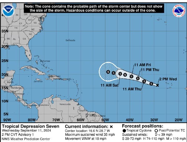
TROPICAL DEPRESSION SEVEN Tropical Depression Seven has emerged in the eastern Atlantic, marked by a closed circulation center and organized deep
Tropical Depression Seven has emerged in the eastern Atlantic, marked by a closed circulation center and organized deep convection observed via satellite imagery. The initial intensity is estimated at 30 knots based on scatterometer data.
The depression is currently moving west-northwest, steered by a subtropical ridge north of the Azores. Confidence in the track diminishes beyond 72 hours as the larger weather patterns become more intricate. It is likely to slow down between 72 and 120 hours, caught between two upper-level ridges.
Read: Hurricane Francine Strengthens, Nears Louisiana Landfall
An amplifying trough in the North Atlantic might eventually steer the depression northward, but the timing and extent of this shift depend on how far south the trough extends.
Initially, wind shear is not anticipated to significantly impede development, and sea surface temperatures along the forecast path are favorable, around 27°C. Consequently, the depression is expected to gradually intensify over the next couple of days.
However, increased wind shear and drier air are predicted later, which may limit further strengthening. The current forecast leans towards the predictions of regional hurricane models, indicating more moderate intensification than statistical-dynamical models suggest.
However, if the system moves further north, it could intensify more than currently forecasted.
Please make a small donation to the Tampa Free Press to help sustain independent journalism. Your contribution enables us to continue delivering high-quality, local, and national news coverage.
Android Users: Download our free app to stay up-to-date on the latest news.
Connect with us: Follow the Tampa Free Press on Facebook and Twitter for breaking news and updates.
Sign up: Subscribe to our free newsletter for a curated selection of top stories delivered straight to your inbox.

