August 20, 2020 By: Staff Report TAMPA, Fla.- UPDATE- CLICK HERE FOR THE LATEST. Invest 98L has been upgraded to Tropical Depression 13. This g
August 20, 2020
By: Staff Report
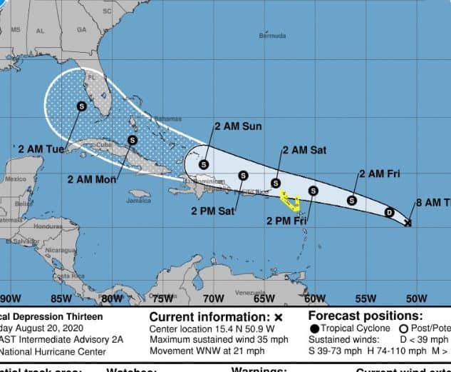
TAMPA, Fla.- UPDATE- CLICK HERE FOR THE LATEST. Invest 98L has been upgraded to Tropical Depression 13. This gives us the advantage of a pretty thorough discussion on the storm from the NHC’s information. As of the 5 AM advisory on Thursday morning, Tropical Depression 13 had winds of 35 MPH and a central pressure of 1008 MB.
The current track sets have converged to a solution that takes the storm south of Miami and up the west coast of Florida to Alabama. The trend from 11 PM last night moved the track a bit south.

The five-day intensity forecast is unusually broad, however. One model has it as a major hurricane (120 MPH winds) and another as a tropical wave (15 MPH winds). The NHC has decided on a compromise of calling it a tropical storm as it passes Fort Myers, FL. It all depends on whether a mass of dry, dusty Saharan air moves south into the path of the storm over the next few days.
The new storm, soon to be Invest 99L, now has a 40% chance of organizing over the next five days. It entered the ocean at almost the same point as TD 13, so has the same unknowns: in which direction, and how strong? This is a storm to watch but don’t take your eyes off of TD 13.

