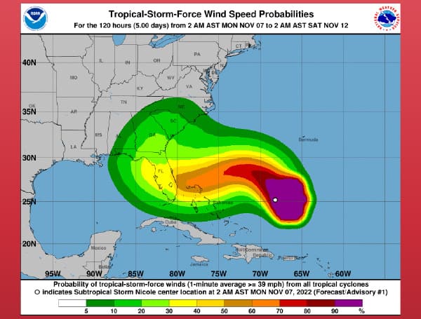
Subtropical Storm Nicole formed Monday morning in the Atlantic Ocean with a projected path that could bring it to Florida’s east coast by Wednesday night.
According to the National Hurricane Center, this storm could be near Hurricane strength as it approaches the state.
As of 8:00 a.m., the system was located about 520 miles east of the northwestern Bahamas with maximum sustained winds of 45 mph moving north-northwest at 14 mph.
The storm is expected to slow down its forward speed later Monday and begin a west-to-west-southwest push from Tuesday to Thursday.
Tropical storm conditions are possible in the northwestern Bahamas by Tuesday night or early Wednesday, according to the NHC.
Nicole is expected to produce rainfall amounts of 2 to 4 inches, with local maxima of 6 inches, across the northwestern Bahamas Tuesday through Thursday.
The five-day forecast cone has the current path bringing the storm close to Florida’s coast by 2 a.m. Thursday with 70 mph sustained winds and gusts up to 85 mph.
The current projected path shows the storm making landfall somewhere between West Palm Beach and Brevard County, and then traveling northwest across the state with the center somewhere between Orlando and Lakeland by mid-Thursday, then shifting Friday and getting pulled back to the northeast up into the southern U.S.
Visit Tampafp.com for Politics, Sports, and National Headlines. Support journalism by clicking here to our GiveSendGo or sign up for our free newsletter by clicking here.
Android Users, Click Here To Download The Free Press App And Never Miss A Story. Follow Us On Facebook Here Or Twitter Here.
Copyright 2022 The Free Press, LLC, tampafp.com. All rights reserved. This material may not be published, broadcast, rewritten, or redistributed.


