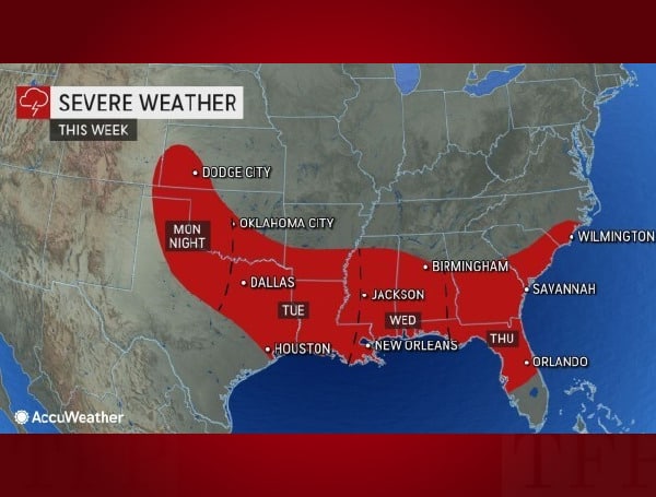
Source: Accuweather A tumultuous weather pattern is set to unfold across the South Central states and the southeastern United States this week as
A tumultuous weather pattern is set to unfold across the South Central states and the southeastern United States this week as severe thunderstorms spawned by a massive cross-country storm system rumble to life.
The same storm that is expected to bring feet of snow and blizzard conditions across the northern Plains this week will bring the risk of severe weather farther south, AccuWeather forecasters say.
Some of the same cities and towns at risk for the severe thunderstorms were recently hit by a deadly tornado outbreak at the end of November.
Prior to the arrival of severe thunderstorms, tranquil but abnormally warm conditions were in place across the southern Plains. The warmth has helped to set the stage for the impending severe thunderstorms.
“The drastic contrast of the warm, humid air ahead of the storm and the cold, dry air following the storm will create the right atmospheric conditions for an eruption of severe weather,” said AccuWeather Meteorologist Renee Duff.
A risk to lives and property is expected to unfold as thunderstorms erupt Monday evening across parts of Kansas, Oklahoma and northern Texas.
In the news: White House Official Says Talks With Russia On Paul Whelan To Happen This Week
The vast majority of the threat is expected to develop well after dark and persist into the early morning hours. These storms will be capable of bringing a wide array of dangerous threats from hail and damaging wind gusts to isolated tornadoes, meteorologists say.
“Residents in this area should be prepared by having a way to get severe weather alerts at night, like the AccuWeather app,” said Duff.
The severe weather threat will not only continue into Tuesday morning, but it will re-energize as the day progresses. Severe thunderstorms will likely become much more widespread on Tuesday and Tuesday night. Because of the increased coverage of the storms and the likelihood for destructive storms to occur after dark, the risk to lives and property will increase significantly.
Some of the cities in the path of the storms from Tuesday to Tuesday night include Little Rock, Arkansas; Shreveport, Louisiana; Jackson, Mississippi; Houston and New Orleans.
Damaging winds of 60-70 mph are expected, with an AccuWeather Local StormMax™ of 80 mph possible in the strongest storms. Multiple strong tornadoes are possible in this zone, along with large hail and torrential downpours.
Motorists along portions of interstates 10, 20, 30, 49, and 55 should be cautious of ponding on highways and reduced visibility in a heavy or gusty downpour. Commuters should be sure to leave extra travel time to reach their destinations.
Across northern and central Missouri, and even into Iowa, gusty winds may accompany any rain that falls on Tuesday and Tuesday night. Even without the presence of severe thunderstorms, the combination of wind and rain could lead to slowed travel in these areas.
By Wednesday, a lot of the potency from the storm will wane, but there will still be a lingering risk for severe thunderstorms. A few tornadoes could accompany damaging winds and hail with any thunderstorms across Mississippi, Alabama, southeastern Louisiana and the western Florida Panhandle. Waterspouts are also a possibility along the immediate Gulf coast.
A new risk will become even more prevalent from the middle of the week as the storm moves towards the East Coast. While the risk for more wintry weather blossoms across the Northeast, the threat of flooding will spread across the Southeast.
“The slow-moving storm could allow for repeated downpours from the Mississippi River to the southeast Atlantic coast late Tuesday through Thursday,” explained Duff.
Widespread rainfall amounts of 1-3 inches are likely from Arkansas and Louisiana to Georgia and the Carolinas, but it will be possible for some locations to pick up more than 3 inches of rain in just a 48-hour time frame.
Visit Tampafp.com for Politics, Sports, and National Headlines, or signup for our free newsletter by clicking here.
Android Users, Click Here To Download The Free Press App And Never Miss A Story. Follow Us On Facebook Here Or Twitter Here.

