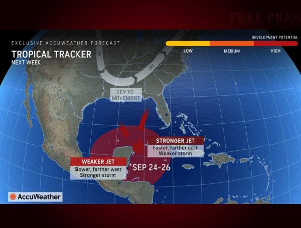
AccuWeather meteorologists are warning of a growing likelihood of a tropical storm or hurricane impacting the U.S. Gulf Coast next week. Residents, businesses, and officials are urged to prepare and be flexible as a storm could form rapidly and leave little time for tracking and preparation.
“We want people to be prepared, not scared. Be ready and be flexible. We could be dealing with a serious hurricane threat on our doorstep by the middle of next week,” said AccuWeather Chief Meteorologist Jon Porter. “We increased the development potential to ‘high’ because we are concerned that a tropical storm can form in the Caribbean or Gulf and approach the United States, and there won’t be many days to track it.”
Read: Hurricane Debby: Florida Agricultural Production Losses Top $93M, UF Economists Estimate
The next tropical storm name on the list for the 2024 Atlantic hurricane season is Helene.
The storm’s path and intensity will depend on a dip in the jet stream. A stronger dip could pull it toward Florida, while a weaker dip could result in a stronger storm heading for the central Gulf Coast. Potential impacts include disruptions to offshore oil and gas operations, refineries, fishing, cruises, and tourism.
“We’re trying to give people as much notice as possible for a reason. There may not be a lot of time to prepare for a landfall once this storm develops,” warned AccuWeather Chief On-Air Meteorologist Bernie Rayno.
AccuWeather Lead Hurricane Expert Alex DaSilva says a forecasted dip in the jet stream is the key factor determining which areas of the U.S. face the greatest risk of a landfalling tropical storm or hurricane.
“The more we look at this forecast and the latest guidance, the more concerned I am about a potential hurricane developing in the Gulf of Mexico next week. All of the ingredients are coming together,” said DaSilva. “There are different avenues that this storm could take, depending on how far south a dip in the jet stream plunges over the Gulf of Mexico. If there is a stronger dip in the jet stream, it is more likely to pull the storm north and east toward Florida. If the trough is a bit weaker, the developing storm could meander further northwest in the Gulf and potentially threaten the central Gulf coast.”
Read: GM Recalls Nearly 450,000 Vehicles Over Brake Warning Issue
“If the dip in the jet stream is strong, it’s going to act like a magnet and quickly pull the storm northward toward Florida next week. A stronger dip in the jet stream would also produce disruptive wind shear throughout the Gulf of Mexico. It would likely be a weaker storm and probably wouldn’t strengthen into a hurricane,” explained Rayno. “If the dip in the jet stream is weaker and we have less wind shear, we’ll likely be dealing with a stronger and slower moving storm into the central Gulf of Mexico. That would be the worst-case scenario. We could be dealing with a hurricane, possibly even a major hurricane, by the later half of next week tracking farther west toward Louisiana.”
Historically, September storms in this region often make landfall between Louisiana and the Big Bend of Florida. The central Gulf Coast currently faces a 38% chance of landfall, while the Florida peninsula has a 17% chance. Texas residents should also remain vigilant as the storm’s path could change.
Clusters of thunderstorms are already organizing in the western Caribbean, and warm ocean temperatures could fuel rapid intensification. Residents are encouraged to check and restock their hurricane emergency kits and supplies.
Please make a small donation to the Tampa Free Press to help sustain independent journalism. Your contribution enables us to continue delivering high-quality, local, and national news coverage.
Android Users: Download our free app to stay up-to-date on the latest news.
Connect with us: Follow the Tampa Free Press on Facebook and Twitter for breaking news and updates.
Sign up: Subscribe to our free newsletter for a curated selection of top stories delivered straight to your inbox.


