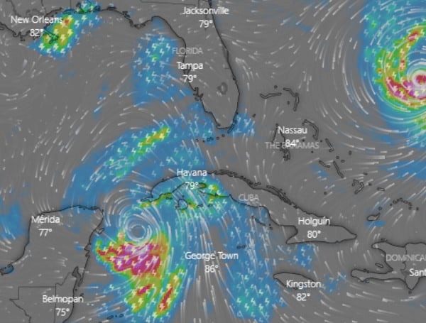
Forecasters said life-threatening storm surge and dangerous winds are becoming increasingly likely for portions of Florida as Tropical Storm Idalia moves north.
Tropical Storm Idalia is expected to strengthen into a hurricane on Monday and reach Category 3 strength by the time it reaches Florida on Wednesday. A Hurricane Watch and Storm Surge Watch have been issued for the Tampa Bay region.
As of 7 a.m. on Monday, Tropical Storm Idalia was located about 90 miles south of the western tip of Cuba. The system had sustained winds of 65 miles an hour with higher gusts and was moving to the north at 8 miles per hour.
In the news: Florida Gov. DeSantis: Be ‘Vigilant’ As Idalia Threatens
The National Hurricane Center is forecasting that Idalia will continue to strengthen as it moves over the warm waters of the Gulf of Mexico. The storm is expected to make landfall in Florida on Wednesday morning as a Category 3 hurricane with winds of up to 115 miles per hour.
The storm surge from Idalia could be as high as 10 feet in some areas of Florida. Residents in coastal areas are urged to take precautions and to stay informed of the latest forecast.
KEY POINTS
- Tropical Storm Idalia has been forming in the Gulf of Mexico.
- As of 5 a.m. on Monday (August 28, 2023), the storm was located about 125 miles south of the western tip of Cuba.
- At that time, it had sustained winds of 65 miles per hour with higher gusts and was moving north at a speed of 7 miles per hour.
- Forecasters anticipated that Idalia would intensify and become a hurricane later on Monday.
- It was projected to further strengthen and become a major hurricane by early Wednesday.
- A Hurricane Watch and Storm Surge Watch had been issued for the Tampa Bay region in anticipation of the storm’s impact.
- The storm was expected to reach Category 3 strength by the time it reached Florida on Wednesday.
- As of 7 a.m. on Monday, Idalia was located about 90 miles south of the western tip of Cuba, with sustained winds of 65 miles per hour and moving north at 8 miles per hour.
WATCHES AND WARNINGS IN EFFECT
Hurricane Warning:
- Pinar del Rio Cuba
Hurricane Watch:
- Englewood to Indian Pass Florida, including Tampa Bay
Tropical Storm Watch:
- South of Englewood to Chokoloskee Florida
- Lower Florida Keys west of the west end of the Seven Mile Bridge
Tropical Storm Warning:
- Yucatan Peninsula from Tulum to Rio Lagartos, including Cozumel
- Isle of Youth Cuba
- Dry Tortugas Florida
Storm Surge Watch:
- Chokoloskee to Indian Pass Florida, including Tampa Bay
Here are some tips on how to prepare for Hurricane Idalia:
- Stay informed of the latest forecast. Monitor the National Hurricane Center website and listen to local news broadcasts for the latest information on Hurricane Idalia.
- Make a plan for your family. Decide where you will go if you need to evacuate, and make sure everyone knows what to do.
- Gather your emergency supplies. This includes food, water, medicine, first-aid kit, flashlights, batteries, radio, and other essential items.
- Secure your home. Bring in outdoor furniture, secure loose items, and board up windows if necessary.
- Have a plan for your pets. Make sure you have a way to evacuate your pets with you, or make arrangements for them to stay with someone else.
- Stay calm and don’t panic. Hurricane Idalia is a serious storm, but it is important to stay calm and follow the instructions of local officials.
Android Users, Click To Download The Free Press App And Never Miss A Story. Follow Us On Facebook and Twitter. Signup for our free newsletter.
We can’t do this without your help; visit our GiveSendGo page and donate any dollar amount; every penny helps


