AccuWeather Experts Urge Florida Gulf Coast To Prepare For Major Hurricane AccuWeather meteorologists are sounding the alarm for a powerful Catego
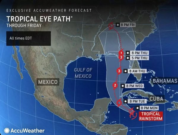
AccuWeather meteorologists are sounding the alarm for a powerful Category 3 hurricane expected to make landfall on the U.S. Gulf Coast this Thursday. With maximum sustained wind gusts of 111-130 mph, the storm poses a significant threat of major storm surge, flooding, and widespread power outages.
“This is expected to be a large hurricane with a major storm surge threat and impacts that will reach hundreds of miles inland from where this storm makes landfall,” said AccuWeather Chief Meteorologist Jon Porter. “We expect significant flooding problems that could reach as far inland as Atlanta and potentially a secondary area of significant flooding in the southern Appalachians.”
Read: Florida Braces For Hurricane Helene, DeSantis Declares State Of Emergency
“People on both the eastern and western sides of our forecast cone need to be prepared. Everyone in the Tampa Bay region should be ready for storm surge impacts, even if this storm stays well offshore,” said DaSilva “We’re closely monitoring a dip in the jet stream that is expected to cross over the Mississippi Valley this week. If it’s a bit stronger and plunges farther south than what we are currently forecasting, it could pull the storm farther west toward Biloxi and Mobile. If the jet stream ends up being faster and a bit weaker, it could steer the storm farther east toward the Big Bend region of Florida.”
The storm, predicted to be large in size, will likely have far-reaching consequences, extending hundreds of miles inland. Significant flooding could reach as far as Atlanta, with a potential secondary flooding zone in the southern Appalachians.
While the storm’s most likely path points towards North Florida’s Big Bend region or the Panhandle, experts warn that impacts will extend well beyond the center, particularly to the east. People along the Gulf Coast from southwestern Florida to Louisiana need to stay alert and monitor forecasts closely.
Read: Hurricane Debby: Florida Agricultural Production Losses Top $93M, UF Economists Estimate
Favorable conditions in the Gulf of Mexico, including warm ocean waters and low wind shear, could lead to rapid intensification of the storm. The exact track remains somewhat uncertain, with a possibility of the storm shifting west or east depending on the strength and speed of a jet stream dip expected this week.
Residents in the potential impact zone should prepare for heavy rainfall, strong winds, and storm surge. AccuWeather predicts 8-12 inches of rainfall near landfall, with the potential for up to 24 inches in some areas. This could cause widespread flooding and travel disruptions. Wind gusts of 60-80 mph are expected across the Florida Panhandle, southern Georgia, and Alabama. Near landfall, wind gusts could reach 140-150 mph, causing significant damage and power outages.
Read: Florida Fish And Wildlife Urges Boaters To Prepare For Potential Tropical Cyclone Nine
Storm surge, potentially reaching 10-15 feet in some areas, poses a life-threatening risk. Residents from Mobile, Alabama, to Fort Myers, Florida, should prepare for 1-3 feet of storm surge. The Big Bend region of Florida could see a 6- to 10-foot surge, while areas from Panama City Beach to Tampa Bay could experience 3-6 feet of surge.
Please make a small donation to the Tampa Free Press to help sustain independent journalism. Your contribution enables us to continue delivering high-quality, local, and national news coverage.
Android Users: Download our free app to stay up-to-date on the latest news.
Connect with us: Follow the Tampa Free Press on Facebook and Twitter for breaking news and updates.
Sign up: Subscribe to our free newsletter for a curated selection of top stories delivered straight to your inbox.

