Winter Weather Outlooks - Climate Change Predictions and Hurricane Predictions - Powered by ClimtePulse Technology Shows warm Equatorial Pacific Ocean

Winter Weather Outlooks – Climate Change Predictions and Hurricane Predictions – Powered by ClimtePulse Technology

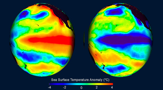
Shows warm Equatorial Pacific Ocean water temperatures – in the warm phase El Niño (left), and cold ocean water in the cold La Niña phase. Courtesy Woods Hole Oceanic Institute

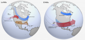
Shows atmospheric steering currents during a La Niña event (left) and El Niña (right)
La Niña event and a ClimatePulse Cycle will be instrumental in changing weather patterns across much of North America and Europe.
TAMPA, FLORIDA, UNITED STATES, February 3, 2024 /EINPresswire.com/ — The winter of (2023-24) was very erratic and chaotic in many areas of the United States northward through Canada into Alaska. Some areas experienced bouts of cold weather not seen in 15 to 30 years – while other areas saw periods of either mild or cooler weather than normal, floods, tornadoes, freezing rain and some big snowstorms.
Much of the erratic weather was due to a strong El Niño event that cyclically occurs about every 3 to 5 years. When it occurs – the ocean water along the Equatorial Tropical Pacific Ocean becomes dramatically warmer than normal (see graphic) – and this in turn causes a major shift in weather patterns across much of North America. The El Niño event also causes a clash between cold air to the north and warm air being transported in from the Equatorial Tropical Pacific Ocean – this in turn causes strong winter storms and chaotic weather.
Looking Ahead to the 2024-25 Winter.
Professor David Dilley (senior meteorologist/climatologist Global Weather Oscillations) – is predicting the winter from November 2024 into March 2025 – will be totally different than the outgoing 2023-24 winter. The predictions by Professor Dilley utilize ClimatePulse Technology that tracks and predicts La Niña events and climate cycles – and he predicts that there will be a total flip in the weather with a very different scenario.
The El Niño event of 2024 will be replaced by a La Niña event along the Equatorial Pacific Ocean. A La Niña event flips the Equatorial Pacific Ocean water from very warm – to much colder than normal ocean water temperatures – and this will be instrumental in changing the weather patterns across much of North America to a more wintry scenario.
Yes, we have a global warming cycle in place that reached its optimum peak in 2024 and is now about to turn in another direction – just like the El Niño flipping over to a La Niña event. There have been 6 global warming cycles since 900 AD, and 5 cyclical global cooling cycles – is #6 beginning to rear its head?
The High Arctic is where Global Warming historically begins and ends, and where the Global Cooling Cycle #6 will begin. The first sign that the current Global Warming Cycle is beginning its transition to Global Cooling Cycle #6 – began during the High Arctic Spring and Summers of 2022 and 2023. Two years in a row – the High Arctic experienced record-breaking cold springs and summers, and in January of 2024 – the greatest Arctic ice extent in 21 years. In response to this, during the winter of 2024 – the region from Alaska through Central and Northern Canada eastward into Scandinavia and Siberia – just experienced a winter not seen in decades – and this is just the beginning.
You can acquire the detailed 2025 winter predictions for the United States and Canada via www.GlobalWeatherOscillations.com. Professor Dilley has 3 Podcast Video Interviews in the climate section that will walk you through climate cycles, what drives the cycles – including atmospheric carbon dioxide.
Professor David Dilley
Global Weather Oscillations
+1 352-789-4461
email us here
Visit us on social media:
Facebook
Twitter
LinkedIn
![]()
